
Iron Creek Falls
Gifford Pinchot National Forest
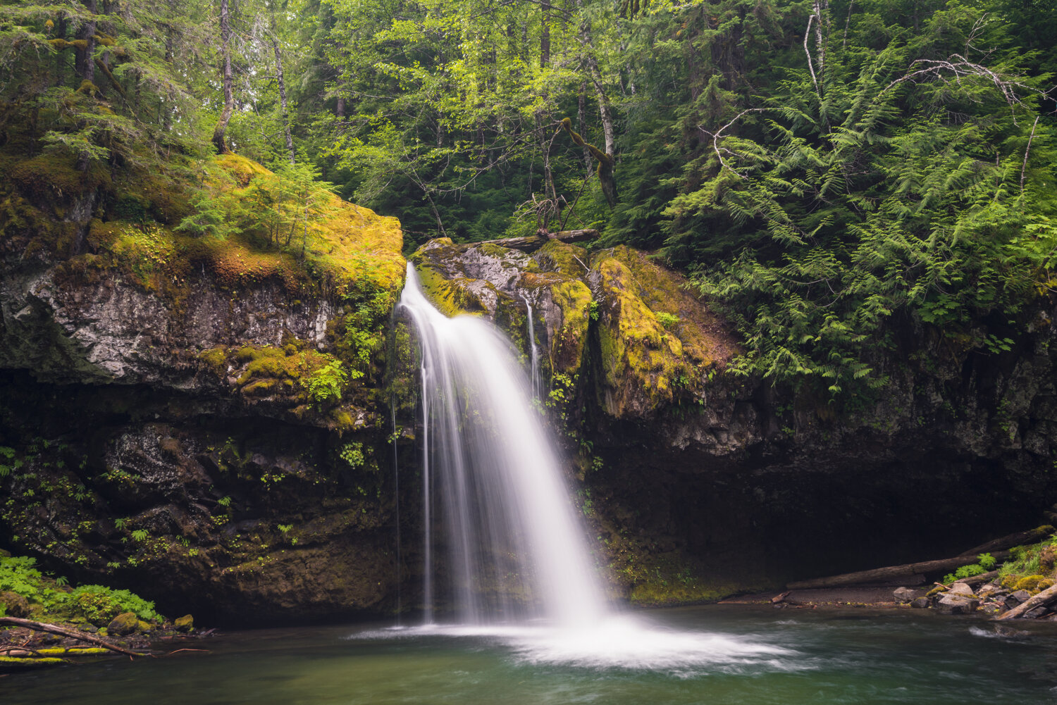
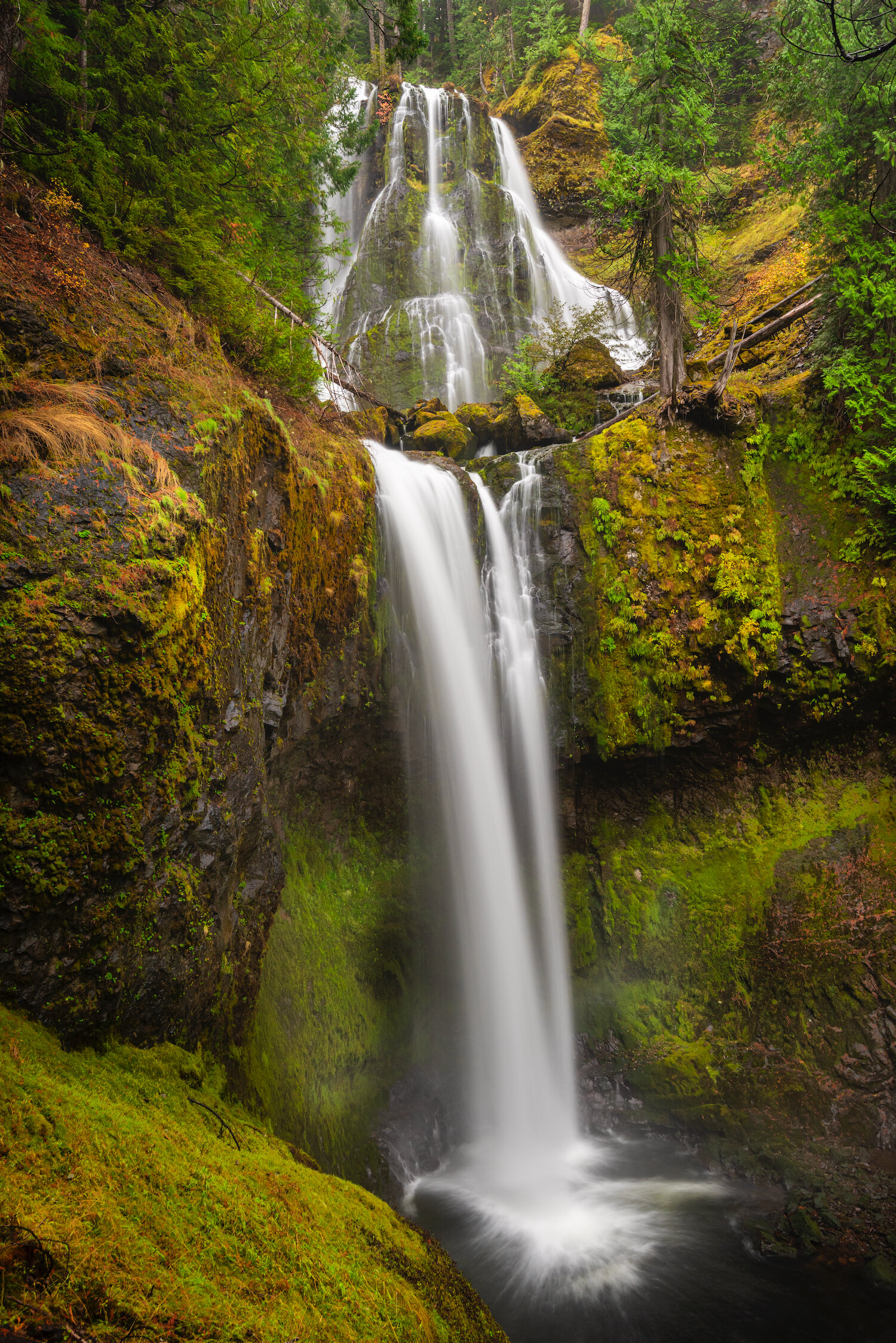
Encompassing the foothills surrounding both Mount St. Helens and Mount Adams and the spine of the Cascades in southern Washington, Gifford Pinchot National Forest is packed with amazing waterfalls. Iron Creek Falls and Falls Creek Falls, for example, are waterfalls with beautiful semi-circular ledges that funnel water over moss-laden cliffs. Similarly, Spirit Falls, near the Columbia River Gorge and surrounded by private land, is actually three waterfalls that drop into a beautiful turquoise pool and churn around. The water is eventually expelled forcefully into a lake downstream and then into the Gorge. Panther Creek Falls is located further north and is comprised of a series of small ribbons of water that drop over a hundred feet. The water flows between moss clinging to a rock cliff before consolidating and dropping a second time.
All three waterfalls exist in incredibly lush, verdant forests, contributing to the visually stunning environment.
Falls Creek Falls

Spirit Falls

Panther Creek Falls
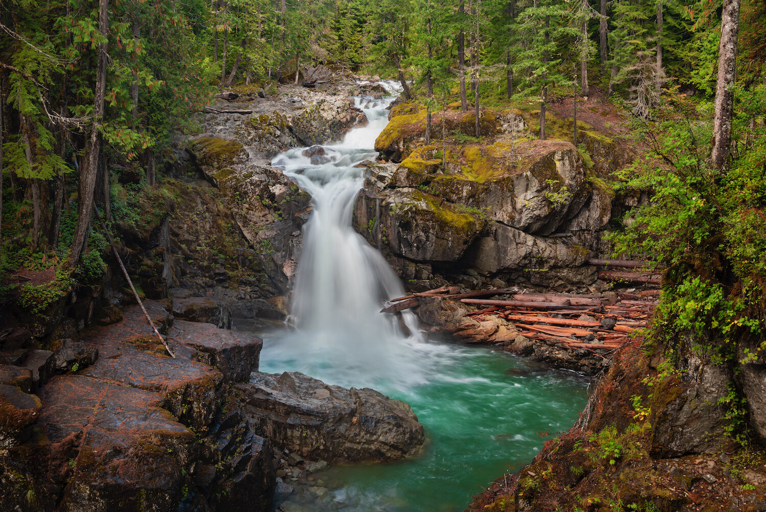
The National Forest is also home to the Lewis River area, named after the major tributary of the Columbia River and home to some of the most stunning riverside landscapes in southern Washington. Adventurous hikers can explore on foot along the classic Lewis River Trail, which follows the banks of the river for approximately 14 miles, starting near the Swift Reservoir. The northern section of this trail is home to three waterfalls—Lower, Middle, and Upper Falls—as well as Copper Creek Falls in between them. Those unwilling to make the long hike can also easily access these waterfalls right off National Forest Road 90.
The Forest Road also affords access to two other magnificent waterfalls. To the north, the Twin Falls Campground is home to Twin Falls, a small yet beautiful waterfall named for its repeating cascade. To the south, travelers can explore the roadside Big Creek Falls. The trail has been decommissioned and is therefore unmarked. Vegetation is beginning to overtake the sightlines and the path to the waterfall, but the deep canyon that it drops into is well worth the visit.

Lower Lewis River Falls

Upper Lewis Falls (during high flow)

Middle Lewis River Falls

Upper Lewis River Falls (during low flow)
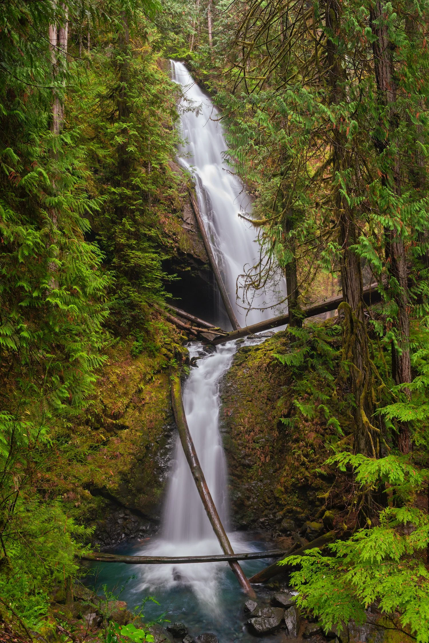
Perhaps most remarkably, the southern end of the Lewis River Trail is home to the double-arched Curly Creek Falls. The water here runs down the hillside and past two naturally formed arches. It’s an extremely rare natural phenomenon—so much so that there might only be a small number of waterfalls like this anywhere in the world.
The waterfall is seen from an elevated perspective across the river, and there are a few trees and shrubs that prevent an uninterrupted view. However, the vegetation overgrowth gives the waterfall a sense of timeless beauty. Curly Creek Falls is a seasonal waterfall that often runs dry as late summer arrives.

Twin Falls

Curly Creek Falls

Copper Creek Falls

Big Creek Falls
columbia River Gorge National Scenic Area
The Gorge is the Northwest’s unofficial waterfall capital, teeming with stunning waterfalls of all shapes and sizes. Most of the best waterfalls are on the Oregon side of the Gorge, profiled in this guide. However, there are three notable cascades on the northern side that are worth a detour. The first, Duncan Creek Falls, is a series of falls flowing through a lush forest by the unlogged banks of Duncan Creek. The water splits into two and later converges various times, forming numerous unique compositions. The second, Rodney Falls, an 80-foot giant, is a little over a mile from the Hamilton Mountain trailhead and is best experienced in the wet months during winter and spring. Later in the year, its flow volume is less impressive. The last, Dog Creek Falls, is right off Highway 14 and is a nice detour to stretch the legs and perhaps get the feet wet in the waterfall’s gentle flow.

Duncan Creek Falls

Dog Creek Falls

Rodney Falls
north cascades & Mount Baker-Snoqualmie national forest
Northern Washington is one of the rainiest and snowiest parts of the state. The steep terrains around Mount Baker are particularly ripe for waterfall hunters to explore. The deep snowpack of some of the peaks around here ensures year-round flow. Nooksack Falls is a dynamic waterfall, particularly later in the summer as the flow splits into two. The viewpoint is also interesting because from it, one can see the water descend nearly 100 feet into a deep canyon and continue flowing along the North Fork of the Nooksack River. Nearby Racehorse Falls’ smooth, gliding, cascading flow makes it unique among the many waterfalls in the state.

Racehorse Falls

Nooksack Falls

Feature Show Falls

Ketchum Creek Falls
Further south, Highway 20 is an amazing drive between the mountains with views of enormous but distant waterfalls across the Skagit River—perhaps too distant for a compelling photograph. However, smaller waterfalls like Ketchum Creek Falls, which flow into the Skagit, are definitely worth a rest stop.
The Darrington area, another entry point into the North Cascades, contains a number of valleys from which two waterfalls are particularly famous: North Fork Sauk Falls off Forest Road 49 and Feature Show Falls in the beautiful Boulder River valley off Highway 2010.

North Fork Sauk Falls

Mohawk Falls
mount rainier national park
The tallest mountain in the Pacific Northwest is surrounded by waterfalls created by the wet weather patterns generated by the peak and the snowmelt from its various glaciers and snowfields. Many photogenic waterfalls are actually quite close to the mountain itself and can be observed from a few of the roads that traverse the National Park: Paradise Road, Stevens Canyon Road, Highway 123, etc.
Stevens Canyon Road and its connection to Paradise Valley Road is a great place to start if looking for roadside waterfalls. From the park entrance near Longmire, traveling east, tourists can begin at Christine Falls, perhaps one of the most scenic in the park, as it is framed by the arch of the road above. The road then crosses the giant Narada Falls; the small but gorgeous Sunbeam Falls; the section of the Wonderland Trail that leads down to Martha Falls; and Silver Falls, one of my favorites in the park.

Christine Falls

Sunbeam Falls
Silver Falls

Martha Falls
Of course, several of the park’s trails also contain beautiful examples, including the wonderful Spray Park Trail, home to the huge Spray Falls as well as a number of other smaller waterfalls dropping from alpine heights. Nearby, on the Green Lake Trail, hikers encounter Ranger Falls, a 172-foot tiered horsetail waterfall halfway up the climb.

Ranger Falls

Spray Park Little Waterfall
The Mather Memorial Highway portion of Highway 410, which runs north-south east of Mount Rainier, is home to Union Creek Falls, one of the more unique waterfalls in the region as it falls behind two rock walls. The walls are so saturated by the spray that small plants have grown on them.
Further south, on Highway 123, motorists can observe the tall, cascading Zigzag Falls right off the side of the road, and hikers on the Eastside Trail can visit the very colorful Stafford Falls. These two waterfalls are among the many attractions that the Rainier highway system provides access to and are produced by the vertical terrain that surrounds the peak.

Union Creek Falls

Stafford Falls

Zigzag Falls
Olympic National Park
As one of the wettest places in the country, Olympic National Park is home to a few landmark waterfalls. Among the best places to explore them are the Sol Duc River, Wynoochee River, Lake Crescent, and the south shore of Lake Quinault—all of which are temperate rainforests surrounded by mountains. Sol Duc Falls may be among the most famous waterfalls in the park and perhaps one of the most unique, as it funnels river water into four distinct drainages. Its proximity to hot springs also makes it a popular attraction. The north side of the Peninsula is also home to Beaver Falls and Marymere Falls, the former located off an unmarked parking lot and the latter accessed after a walk through giant, old-growth trees.

Sol Duc Waterfall

Beaver Falls

Marymere Falls
The south side of the park contains three amazing waterfalls that drain into the Wynoochee River (Wynoochee Falls, Clark Creek Falls, and Maidenhair Falls) and can be accessed off Forest Road 2312, the first two of which are pictured here. South Shore Road on Lake Quinault provides access to the Quinault National Recreation Trail System, a series of trails where ample precipitation filtering down from the hillsides creates cascades like Willaby Creek Falls and Merriman Falls, which exist in highly photogenic settings.

Clark Creek Falls

Willaby Creek Falls

Wynoochee Falls
Murhut Falls

Merriman Falls